Your shopping cart is empty!
All Categories
- All Categories
- Accessories
- Antennas
- Autopilots
- Battery Charger
- Cables
- Cameras
- Chartplotter
- Charts
- Communication
- Fishfinders
- GPS
- Installation Accessories
- Instruments
- Lights
- Minn Kota Accessories
- Mounts
- Multi-Function Display
- Radars
- Safety
- Satellite TV Antennas
- Security System
- Stereos
- Transducers
- Trolling Motor
- Weather
Categories
- Accessories (388) +
- Antennas (89) +
- Autopilots (86) +
- Battery Charger (8)
- Cables (15)
- Cameras (22) +
- Chartplotter (101) +
- Charts (23)
- Communication (95) +
- Fishfinders (95) +
- GPS (16)
- Installation Accessories (194) +
- Instruments (65) +
- Lights (72) +
- Minn Kota Accessories (6)
- Mounts (53) +
- Multi-Function Display (27) +
- Radars (96) +
- Safety (19) +
- Satellite TV Antennas (8) +
- Security System (15)
- Stereos (116) +
- Transducers (220) +
- Trolling Motor (17)
- Weather (5)
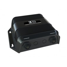
Simrad Structurescan 3D transducer and module
StructureScan® 3D imaging scans underwater terrain and fish-holding structure to create a high-resolution, 180-degree, th... Learn More »
Product Code: 000-12395-001
Availability: In Stock
Availability: In Stock
Qty:
Simrad Structurescan 3D transducer and module
StructureScan® 3D imaging scans underwater terrain and fish-holding structure to create a high-resolution, 180-degree, three-dimensional view beneath your vessel. With this unique imaging view, anglers gain a better understanding of where fish and structure are located in relation to their vessel. The picture-like, three-dimensional views are displayed on the Simrad NSS evo2 and NSO evo2 echosounders/chartplotters, when used in combination with the SideScan 3D Skimmer® transducer and StructureScan® 3D module.
Starboard Marine © 2025 - Powered By OpenCart

